Microseismic monitoring of the Lithium de France
project in Schwabwiller
Infos
Why continuously monitor and analyse the subsurface around our operations?
Located upper Rhine Graben, the Lithium de France project in Schwabwiller is being developed in a region with moderate natural seismicity. Operations related to the production of geothermal heat and lithium interact with existing geological structures and generate subsurface movements. This phenomenon, known as induced seismicity, observed throughout the world, is well studied by experts. Such earthquakes are much often of very low amplitude and they are barely perceptible at the surface.ible at the surface.
To ensure control of these seismic events, a continuous monitoring system has been implemented. Any unusual variation detected immediately triggers corrective measures, such as adjusting water flow rates, in accordance with strict safety protocols that are a prerequisite for any drilling authorisation.
A supervised activity
The operation of a geothermal well is regulated and monitored before, during and after the drilling phase. The aim is to monitor ground movements, keeping them well below the threshold of perception and preventing any potential damage.
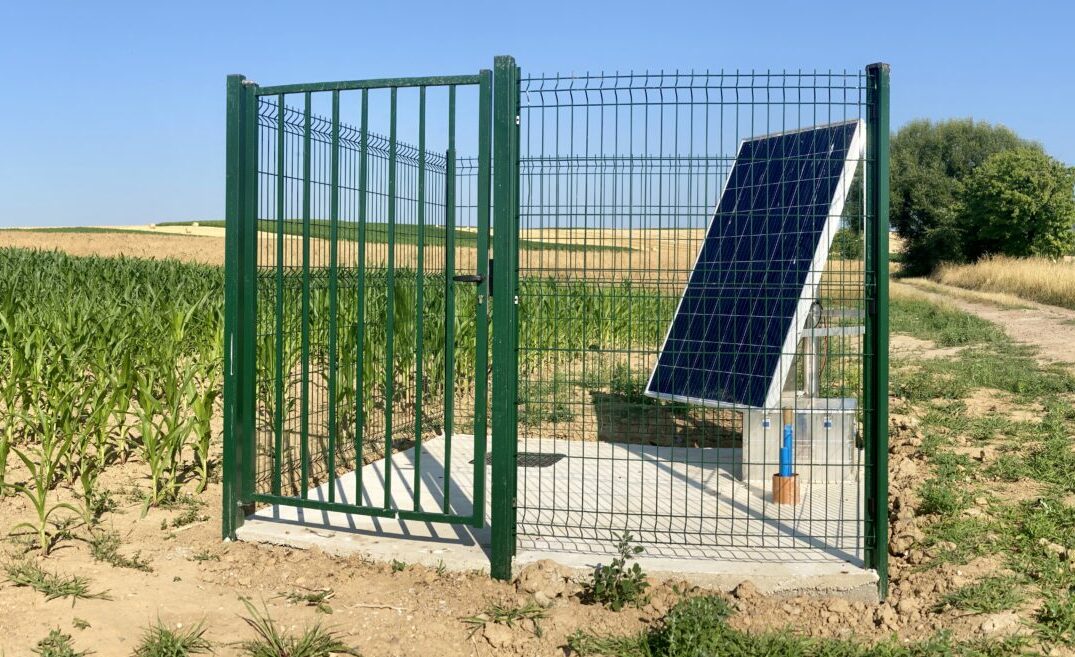
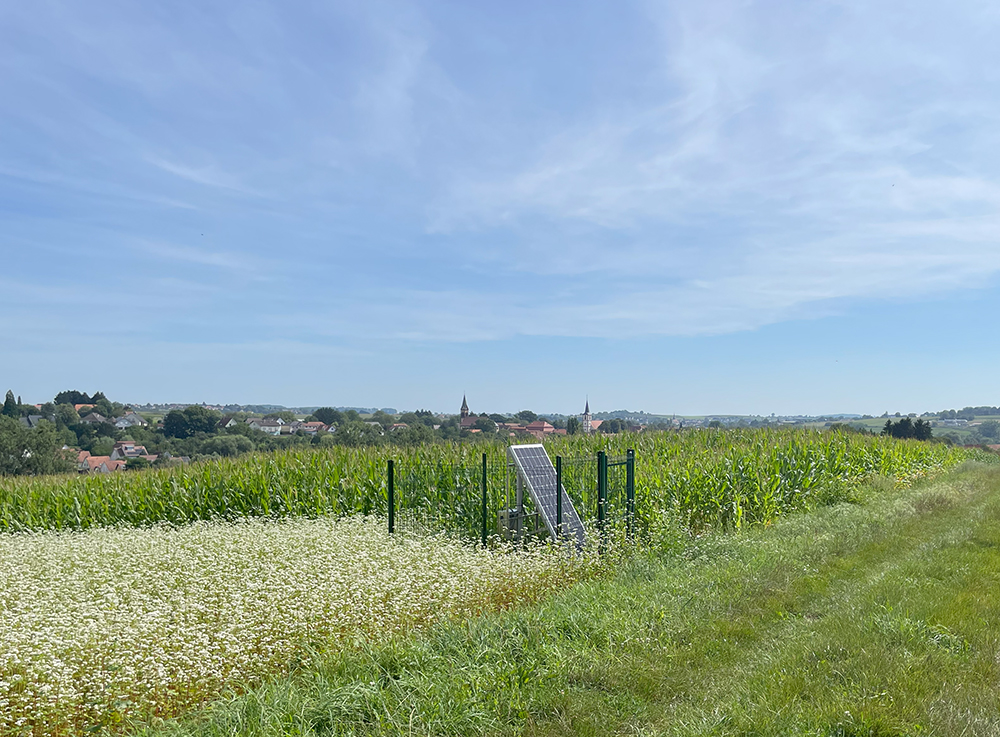
Networked of monitoring stations
A network of monitoring stations equipped with seismometers has been set up around Schwabwiller to :
- continuously monitor ground movements, whether related to ongoing operations or not associated with the operations being carried out;
- detect, locate and estimate the magnitude of both natural and induced seismicity;
- enable operational adjustments in response to changes in subsurface behaviour.
Continuous monitoring for well-managed operations
Operations are continuously monitored and adjusted in line with the activity recorded by sensors across the monitoring network.
This control is implented through a system known as the TLS (traffic light system), based on thresholds validated by the Regional Directorate for the Environment, Planning and Housing (DREAL) and by independent experts. It enables the adjustment of key operational parameters, including injection or production flow rates, pressures, and volumes.
These thresholds are specific to each project and each operational phase. They are defined based on two indicators that enable near real-time operational responsiveness:
- Local magnitude (ML)
Measures the energy released by an earthquake. It is calculated based on the amplitude of the seismic waves recorded by the seismometers in the monitoring network set up around Schwabwiller.
- Peak Ground Velocity (PGV)
Maximum ground velocity recorded during an earthquake at a given location. It is used to characterise ground vibration at the surface and thus the potential impact on people and buildings. The PGV is expressed in millimetres per second (mm/s) and is recorded at the Lithium de France measuring stations.
TLS thresholds for the drilling phase at Schwabwiller*:
*PGV thresholds apply to at least two monitoring stations.
| Green | ML ≤ 0,5 and PGV ≤ 0,5 mm/s | Normal level Operations continue as planned. |
| Yellow | 0,5 < ML < 1,7 or 0,5 mm/s < PGV < 1 mm/s | Vigilance Strengthening of the monitoring network. |
| Orange | 1,7 ≤ ML < 2 or 1 mm/s ≤ PGV < 1,5 mm/s | Heightened vigilance Analysis of the event and submission of findings to the DREAL. Wellhead pressure maintained below the pressure at which the event occurred. |
| Red | ML ≥ 2 and PGV ≥ 1,5 mm/s | Gradual shutdown of operations and implementation of safety measures. Analysis of the event and submission of findings to the DREAL. Resumption of operations subject to the Prefect’s approval. |
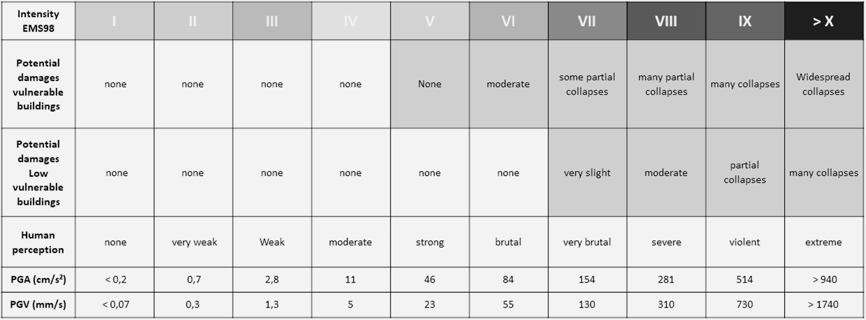
The thresholds for this TLS system are well below the intensity levels associated with the onset of potential damage to buildings on the surface:
Microseismic monitoring
Providing information to the public, sharing data, and explaining the underlying processes are an integral part of our commitment to transparency.
This map shows all seismic events of magnitude 1 or greater detected by our sensors and located within the monitoring perimeter of our network of seismic stations.